ILWIS Academic versions

Handy tool for vectors, raster and satellite imagery needs
3.3
Nov 7, 2021
Editorial review
rating
3.2
Apr 4, 2008
3.1
Aug 18, 2008
3.0
Aug 3, 2008
Review

What's new

v3.3 [Mar 1, 2008]
- Spatial Multiple Criteria Evaluation (SMCE)
- Hydrological Operations
- Georeference Editors
- Import and export using the GDAL library
- Satellite projections
- Calculation and statistical functions for MapLists

Alternative downloads

MapCreator
MapCreator
rating

Create static and animated maps.

GRASS GIS
GRASS GIS
Free
rating

Contains over 350 modules to render maps and images on monitor and paper.

Raster to Vector
Raster to Vector
rating

Convert raster image formats to DXF, HPGL, EMF, and WMF.

VeryPDF Raster to Vector
rating

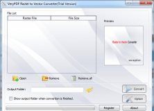
Raster to Vector Converter is used to convert raster files to vector files.

TrackLogs Digital Mapping
rating

Plan, navigate, analyse and print routes on your Windows PC.